Friday, December 7, 2012

Fall Colors

This post is a little late, but this year the colors along the river at the park were crazy pretty. Bright yellow cottonwood trees. I'll admit that's one thing this park has over Dead Horse Point. We're close to the river and we've got trees that actually change color in the fall. Single-leaf ash was the only deciduous tree at DHP and I don't remember them being quite this impressive.


This was taken in the picnic area. This fall, the Carson River totally dried up so we didn't have any water for a while at the park, but now it's almost full and Horse Camp actually flooded. One spring Scout Camp flooded and that's the campground that groups use the most so it hurt our visitation a lot.

This is Horse Camp with extra water...

Friday, October 12, 2012

Sunset at Mason Valley WMA

On the way home from the store, I saw a coyote running down the dirt road between the houses. The sunset was so pretty, I decided to get my glass of wine (this time in a plastic cup) and walk to the bridge over the Walker River to watch. I saw raccoon tracks and heard turkeys, flickers, lots of other birds, frogs and bugs chirpping. I also saw a heron sitting on a piece of irrigation equipment and a spider working on its web.

I don't think they show up in the picture but in the center on the left there are four deer watching me while I watch the sunset. This is the Walker River that runs through Mason Valley.
 
....and this is the sunset from the bridge. Not bad for a 5-minute walk!
 
I spent most of the day in Reno so it was great to be outside relaxing after all that!
 

Saturday, September 29, 2012

Civil War Hardtack


This morning I don't have to work until noon so I have the whole morning to catch up. I slept in a little (very little)...did dishes and laundry...and now I'm making some hardtack for my full moon hike tonight.

Hardtack is an unleavened bread that was used in the Civil War. Soldiers were always traveling so they needed food that would be easy to carry and not go bad. Hardtack is made from flour, salt and water, then baked "to the consistency of a brick." I found the recipe here.

My first batch was way too bland--I didn't add enough salt! The 2nd batch was a lot better. This will be my 3rd batch for the year and probably the last until spring so hopefully it works.

The full moon hikes start at the museum. I do a short introduction, then we head down the hill to the Officer's Quarters. At the Officer's Quarters I talk about the history of the fort and about the quarters themselves. Then we head to the barracks and then the mess hall. At the mess hall, I talk about food the soldiers would have been given, then I pass out the hardtack...after I warn people that it is really hard and to watch their teeth! Other names for it are "jawbreaker," seabiscuit," and "tooth-duller." Hm.

Anyway tonight is my last full moon hike for a while, probably until May or June so hopefully it goes well!


Sunday, September 23, 2012

Wayne E. Kirch Wildlife Management Area

This is where Dave worked for the summer. I hope I haven't posted these before, but I'm behind on blogging this summer and thought I'd share one of the really cool areas of Nevada I got to visit this summer!

One thing I love about Nevada is the amount of wetland areas within the Great Basin. I didn't expect so many...but the reason it's called the Great Basin is that none of the rivers flow from the basin to the ocean. Instead they create wetlands or sinks, where the water goes underground.


Hotsprings! I only dipped my hand in the water but it was pretty warm...and such a pretty area!


Ducks at sunset...


I don't think I'd ever seen an ibis up close before.

While I was looking at the ibis, I noticed this tarantula hawk in the flowers next to me.

Fort Churchill Summer

I really liked this picture and wanted to share! It's a view of the Fort Churchill ruins from the Fort Churchill Road, which is part of the old Pony Express route. The mountains in the background are the Pine Nuts.

Thursday, August 16, 2012

Sunset

I love sunsets! I always have and I've always thought Vernal, UT had the best sunsets ever, but tonight's was pretty good too:


And...


I won't complain :)


Saturday, June 16, 2012

Pony Express Re-ride.. Part 1

I have to admit I was really nervous about this event. Not only was it my first one ever, the event took place just outside of the park, while other events took place inside the park! Also, I advertised this event to take place on the other side of the park, but at the meeting last week, I discovered it had been moved to the main side of the park, along the Fort Churchill Road. Oops! So I spent a lot of time re-advertising the new location and making and hanging flyers and signs to announce the new location!

The Pony Express re-ride happens once a year, alternating between east and west. This year, the riders took off from Sacramento, CA and headed the almost 2,000 miles towards St. Joseph, Missouri. I love the Pony Express, so as nervous as I was for this event, I was really excited for it too.


National Pony Express Association members wearing the traditional "uniform."

I advertised the event to start at 4 p.m. with the Civil War Volunteers and Nevada Calvary kicking things off. 4 p.m. came and went, with no one showing up. The Pony Express Association members were coming back and forth, letting us know when the mail exchange was to happen, so when we got word that the rider was only 4 miles away I started moving people towards the Fort Churchill Road. Some drove, some walked the short distance through the gate outside the park.

We got word that although two riders were thrown from their horses, the riders were an hour early so instead of the mail exchange happening at 6 p.m. (as advertised) it happened around 5 p.m. I was SO worried someone would show up at 6 expecting to see the mail exchange and the programs scheduled but everyone apparently took my suggestion to show up early, as horses don't carry watches! hahaha

My pictures of the re-ride itself are at work so I will have to post those later...meanwhile, here are some others. I was asked to give a history talk about Fort Churhill and fire the cannon. After my talk, David Kittle gave a talk about the history of the Pony Express. I will post more about his speech when I post my pictures of the re-ride because I think it will have more meaning.

Me, with the National Pony Express Association members!!


A spur-of-the-moment decision was made to induct two new members into the association. I got to see a swearing-in ceremony for the first time. SO cool!


Not the best picture of me, but I was giving a talk to about 35 people and PRAYING the cannon would go off for me! It worked and everyone was happy!


David Kittle, giving his presentation about the XP history.


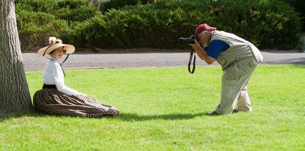
Local photographer capturing women in period costume...

I really like seeing people in period costumes. I did feel bad for these women dressed in such heavy clothes in this heat though!

Another ...interesting....picture of me, but this is Richard Massey, the park's photographer.

Fernley Intermediate School Special Olympics

A while back, I got an e-mail from our region manager, Bob. He said he's not usually in the habbit of volunteering people for things, but he was talking to the person in charge of the Special Olympics at Fernley Intermediate School and my name came up. She wanted people from as many different agencies as possible to set up a booth at the Special Olympics to provide as many different opportunities for the athletes as possible. He volunteered me because I have a background in interpretation and I've also got supplies like animal skins and replicas of animal tracks and scat.

I brought a map of the Carson River Watershed and some examples of animals that live along that watershed. Bob gave me some junior ranger stickers and I handed them out to the athletes and their helpers. There were over 40 schools involved from 10 counties in Nevada. The school that came the furthest was from Hawthorne. There were over 400 athletes involved and each athlete had a student helper to take them through the games and events.

The man standing to the left is the principal of the school...cheering everyone on. I heard some of the most motivating speeches that day. They did an awesome job with this! Last year they only had a little over 100 participants and that grew to over 400 this year. I was impressed.


The event started with a parade, with all the athletes walking around the track holding banners that represented their school. Like any parade, they had a police, fire truck and ambulance escort complete with lights and sirens. My picture didn't quite work out but they also had a crane with the American flag and Nevada state flags represented. We started with the pledge and a performance of the National Anthem...which I couldn't hear because a couple of men standing nearby had a very loud conversation... but the rest of the experience was totally positive :)


I also got to hang out with Bruno Bighorn! I think he was a mascott for one of the local basketball teams...I don't remember, but he was the cutest "guy" I've ever seen!

Side note: it's not a good idea to wear shorts with winter-white legs and forget your sunscreen! Very bad idea....

Loneliest Highway in America

Highway 50 is called the Loneliest Highway in America. I drove it on my trip out to visit Dave when he started his job at the Kirch Wildlife Management Area, about an hour south of Ely, NV. I decided to take the day to drive out there, starting with breakfast in Fallon and continuing through. Highway 50 goes across the middle of the state and follows a lot of the old Pony Express trail. The Pony Express to me is fasinating, even though it only lasted 18 months, from 1860 to 1861. I've got at least two posts covering the Pony Express, so that's all about it for now...except a couple pictures of an old station.

One of my first stops was an area outside of Fallon that had some rock art. I'm hoping to get out there more as soon as I can!

I do miss Moab's rock art, but I'm happy to know that Nevada's got some too!


I missed one Pony Express station outside of Fallon, near Sand Mountain, so I made sure to stop at this one--New Pass Station. I was kind of sad to see it surrounded by chain link fence, but I know it would probably get vandalized if it wasn't protected. There is an old station between Fort Churchill and our region office. I have pictures of it at work, so I'll have to post those soon. It isn't protected with a fence, but it's so remote that to get to it you have to know about it. My previous supervisor pointed it out to me one day and I finally made the trip over to it.


Ward Charcoal Ovens

When Dave first started his job outside of Ely, I drove out there on my days off. I decided to take the whole day to drive out there, then we drove back the next day after he got off work. I'll post a few pictures of the drive soon, but the 2nd day I was there, I went to a couple state parks nearby in the morning.

Ward Charcoal Ovens was the first park I went to. It's a state historic park like Fort Churchill. It also has a campground and hiking trails.


The ovens were used to produce charcoal. Nearby trees were cut down and stacked inside. They were then lit on fire and slits in the walls (visible near the bottom) were used to control the heat and speed of burning. They didn't want the wood to burn too fast, because then it would produce ash instead of charcoal. These ovens were used from 1876 through 1879 and use stopped when the available timber ran out. After they were no longer used to produce charcoal, they served as shelter for prospecters and eventually outlaws like Butch Cassidy.


A really good friend of Dave's, Allen Wooldridge, is the ranger at Ward Charcoal and Cave Lake State Parks. They are so close together, the same supervisors and rangers patrol both parks. Allen lives at Ward Charcoal. These are his chickens!


Allen also "bribes" local ducks to live at his pond so they clean out the algae. He has some pretty good-sized fish in there too. I wish I'd had my camera, instead of my cell phone for pictures because that area is beautiful! I don't have any pictures yet of Cave Lake but I definitely want to go back.

Monday, May 21, 2012

Full Moon Hike

I did full moon hikes at Dead Horse Point and they were pretty popular, so I decided to try some here at Fort Churchill. There is an easy 0.6-mile trail that goes around the ruins of the Fort so I thought I'd start by talking about the moon (on May 5--the first hike--it was a Perigee moon, where it was at its closest point to the earth and a full moon) then talking about the history of the Fort. As we walked through the fort ruins, I wanted to stop and talk about the buildings and what life was like for the soldiers. I made hardtack, which they would have eaten as they traveled because it's light and stores well.

The moon just starting to rise over the mountains.

We advertise in the newspapers, through Nevada Magazine, the Silver Springs Chamber of Commerce, the Nevada Council on Tourism, Facebook and Google Calendar. Even with all that I didn't expect to have 51 people show up! The region manager was there--brought his kids--so I was really nervous because it was the first one and I didn't know what to expect. He told me later that his kids went back for seconds on the hardtack (I thought it was nasty, but I'm glad the kids liked it!).

This is the line of people from the museum down the trail, and more people still hanging out at the museum. I'm curious to see if we have that many people in the next few months.


It ended up going really well--since I was so nervous, I made sure I knew the material really well. I did have to condense some of the stops because sometimes it's a long wait for the whole crowd to catch up every time, but it still lasted about an hour.

Right when I started to talk, the sprinklers went off on the lawn! No one got soaked (maybe a dog or two) but I was still embarassed...next month, the sprinklers are going off the day before! I never had to worry about sprinklers at Dead Horse Point, because we didn't have grass to water! Oops...

It ended up being a really nice night--no wind, no bugs, good temperature...I was happy!

This isn't the clearest picture, but you can just make out the Fort ruins lit up by the moon. I'm thinking maybe it should be scheduled later, when the moon is already up in the sky so it's brighter, but it was also fun to see it rise.

Steller's Jay!

It didn't take long for the visitor to arrive after we set up the campsite...

Got any chips?

Nothing yet....I'll come back later.

This Steller's Jay kept an eye on the campsite in case we left an un-guarded bag of chips or hot dog bun laying around.

Solar Eclipse

This will just be a short post about the eclipse yesterday. Dave tried to get a picture of the sun but the camera wouldn't cooperate (I think he's the one who told me it's bad for the camera...hahaha). I remembered that you can put a pinhole in a piece of paper and project that image onto another paper so we did that instead. Dave tried to get a picture of that too, but he kept blocking the sun with the camera so it didn't work.
This is what it would have looked like, except our image was smaller. The clouds came over before we got to see the whole thing but we did watch it get dark while the sun was covered.

It was pretty exciting--I like that kind of stuff, and it was way better than the movie we were watching!

Thursday, February 16, 2012

Old Cowboy House

Across the highway from where I live, there is an old cowboy house made out of mud (adobe?)! After looking at for a month or so, Dave and I decided to check it out. I wouldn't have gone over by myself.....but it ended up being pretty interesting.

We parked on the road and walked across the field to get to the house. I was surprised there are no fences around it but there are so many of these in the area people pretty much leave them alone.

We guessed that it's been here since the 1800s, since that's when this area was developed. My guess was 1850s or 1860s but I'd have to do more reading about Yerington to know for sure.

We didn't go inside, but Dave stuck his head in a window to get this picture. I'm too much of a chicken to even stick my head in. It does look like it was used "recently" like in the 1940s (again just a guess, I'll do more research) because it was retro-fitted with electricity. From the looks of things though we were smart not to go inside...hantavirus is an issue here and it looks like mice and packrats have been using the place for their own homes.

Another interior view...

Mason Valley Wildlife Management Area Part 1

This will be a two-part post, because some of the pictures are on another camera. It could even be a three-part post. We'll see!

Dave got a new camera so today we went out to the wildlife area and looked for some birds/hawks/falcons to test it out. I took the binoculars too and had a good time looking around and being able to identify birds I wouldn't have known without an up-close look. I also took the smaller camera and took some pictures of my own. We learned that even though we see these birds all the time here, they only stand still when you don't have a camera in your hand!

I loved this view! I call them cattails. Here, they're called "tules" (as in tulies).


Here's another one. This mountain (I need to look it up again to remember the name) is one of my favorite views in Mason Valley. On my drive home from work I can see it the moment I come up over the hill and head towards Wabuska and Yerington. (There will be a later post on Wabuska...)


I love wetlands! This picture didn't turn out looking as bright as it did in real life, but I'm still happy with it.

Here's Dave with his new camera, trying to capture a hawk.

Great view of the Wildlife Management Area boundary.


Couldn't help it...one more view of the cattails!